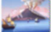
Google Traduction. Whole country - earthquakes during the last 48 hours (Preliminary results) Le volcan islandais Hekla prêt à entrer en éruption "à n’importe quel moment" ? Les prédictions de Páll Einarsson, un géophysicien, laissent à prévoir une éruption imminente du volcan Hekla, l'un des plus actifs d'Islande.
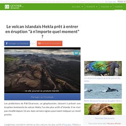
Il ne s'est pas réveillé depuis 16 ans mais certains signes pourraient indiquer un réveil proche. Longtemps considéré comme un des volcans les plus actifs d’Islande, l’Hekla a été surnommé la "Gateway to Hell", littéralement la "porte des enfers". Le cratère a connu plusieurs éruptions régulières entre 1970 et 2000 puis s’est enfin endormi. Cette situation est néanmoins temporaire et pourrait bien prendre fin d’ici peu.
Akureyri.net. Hengill. There are no activity reports for Hengill.
There are no Weekly Reports available for Hengill. Summary of eruption dates and Volcanic Explosivity Indices (VEI). The following references are the sources used for data regarding this volcano. References are linked directly to our volcano data file. Discussion of another volcano or eruption (sometimes far from the one that is the subject of the manuscript) may produce a citation that is not at all apparent from the title. Botz R, Winckler G, Bayer R, Schmitt M, Schmidt M, Garbe-Schonberg D, Stoffers P, Kristjansson J K, 1999. Forage. Stærsti skjálftinn sem mældist á svæðinu var 2,4 á richter.
Hann mældist reyndar í gær.Hjörleifur Sveinbjörnsson, jarðfræðingur, segir skjálftavirknina á Hellisheiðinni eðlilega miðað við rannsóknir á svæðinu. Aðspurður hvort slíkt geti orðið hættulegt svarar hann: „Ef það er verið að bora niður í stórar sprungur þar sem mikil spenna hefur byggst upp, þá gæti þetta orðið hættulegt. " Það er þó ekki búist við því að sögn Hjörleifs. Hann segir þetta ekki í fyrsta skiptið sem slík virkni mælist við jarðhitarannsóknir Orkuveitunnar Í Reykjavík. „Þetta er hluti af þeirra rannsóknarferli til þess að finna réttu sprunguna," útskýrir Hjörleifur. Skjálftavirknin heldur áfram í Kötlu en stærsti skjálftinn frá miðnætti mældist nærri Goðabungu, en hann var 2,6 á richter samkvæmt fyrstu mælingum.
Hjörleifur segir ótrúlega mikla jarðskjálftavirkni á svæðinu. Hengill. VAG_1315475676. Volcan Askja. L’Askja appartient à la zone volcanique de Dyngiufjöll, située sur un système de fissures qui s’étend sur 100 Km environ depuis le glacier Vatnajökull au sud.
L’Askja est constitué de plusieurs calderas emboîtées ainsi que de nombreux cônes de scories alignés sur des fractures éruptives. Un vaste lac occupe la partie sud-est de la caldera principale dont les rebords sud et est sont particulièrement abrupts. Des sondages de ce lac indiquent également la présence d’un cratère circulaire d’une profondeur maximum de 224 m. Plusieurs zones géothermales vigoureuses se sont développées laissant certaines zones exemptes de glace même en hiver. Ask. Vatnajökull - earthquakes during the last 48 hours (Preliminary results) Vöktun Vatnajökuls 2010. Grf_seis_mo. Grf. Grf_trem. Grimsvotn éruption du 21052011. IPPS animation - Meteosat 0 degree Ash Iceland. Chaîne de besobnb
South Korea Play In 2009 we traveled around South Korea by bus and train.

We found a very varied culture with a mix of modern technology and old traditions. Korean food is very spicy and kimchi came as a side dish to almost everything. Apart from its friendly people, tasty food and ease of traveling there is also a fantastic nature in South Korea, that is dotted with nature parks where hiking is taken very seriously. Europes west coast In the summer of 2011 we drove along the west coast of Europe from Denmark to Britanny. Costa Rica roadtrip In january 2011 we drove around in Costa Rica for 3 weeks. Global Sulfur Dioxide Monitoring Home Page. ELDGOS Í EYJAFJALLAJÖKLI. Les débits d'eau. Þessi síða gefur aðgang að vatnshæðarmælum Veðurstofu Íslands.
Til að skoða mælingar skal smella á nafn stöðvar vinstra megin á skjánum, einnig er hægt að smella beint á punkt á korti. Þegar stöð er skoðuð er gögnum skipt í flipa: Gögn: Sýnir nýjustu mælingu frá stöð. Graf: Gefur kost á því að skoða mælisögu á línuriti. Sækja gögn: Leyfir notendum að vista gögn í textaskrá, hægt er að vinna með skrána t.d. í Excel. Road conditions and weather. Conséquences. Journaux. Forsíða. Translate. Veðurstofa Íslands. Iceland Vulcanoes. Iclandic Volcanism. Atlantic Ocean Volcanism, OIBs, Tholeiites and Basanites (Ocean Island Basalts) Iceland is a large mid-North Atlantic island, built entirely of basalts and fractionated derivatives.
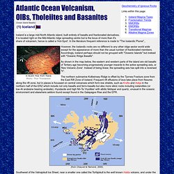
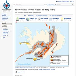
It is located right on the Mid-Atlantic ridge spreading centre but is the locus of more than it's share of volcanism, hence is called a 'Hot-Spot'. In the literature frequent reference is made to "The Icelandic Plume"., However, the Icelandic rocks are no different to any other ridge sector world wide except for the appearance of more than the usual number of fractionated members. As shown in the map below, the eastern and western parts of the island are old basalts of Tertiary age becoming progressively younger inwards to the active spreading axis, or 'Neo Volcanic Zone'. The northern submarine Kolbeinsey Ridge is offset by the Tjornes Fracture zone from the East Rift Zone of Iceland. (from Chauvel & Hemond, 2000) Iceland has it's own characteristics, though similar in general to other basaltic islands. Iceland: Volcanoes in Iceland. Fichier:Volcanic system of Iceland-Map-fr.svg - Wikipédia.
Cancel Edit Delete Preview revert Text of the note (may include Wiki markup) Could not save your note (edit conflict or other problem).
Please copy the text in the edit box below and insert it manually by editing this page. Upon submitting the note will be published multi-licensed under the terms of the CC-BY-SA-3.0 license and of the GFDL, versions 1.2, 1.3, or any later version. See our terms of use for more details. 20ky5x2. 137eefaa9620. Jonfr.com home par Jön Frimann. Renewed earthquake activity in Hekla volcano Today (14-April-2014) an earthquake swarm took place in south part of Hekla volcano.
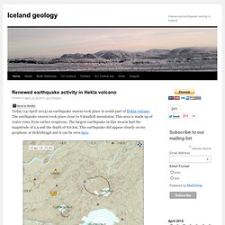
The earthquake swarm took place close to Vatnafjöll mountains. This area is made up of crater rows from earlier eruptions. The largest earthquake in this swarm had the magnitude of 2,9 and the depth of 8,6 km. This earthquake did appear clearly on my geophone at Heklubyggð and it can be seen here. The earthquake swarm in SW Hekla volcano system. N-Atlantic - earthquakes during the last 48 hours (Preliminary results) Tremors. Gps-stations. éruptions en islande. Krysuvik. Katla Webcam Volcano. Katla. Mn2tqr. GPS time series for Eyjafjallajökull and Katla Volcano.
GPS time series for stations around Katla and Eyjafjallajokull volcano.
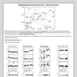
Stations AUST, ENTC, OFEL, RFEL, STE2, FIM2, HAMR and SKOG (DAGF, BAS2, and SVBH) are run by the Institute of Earth Sciences, University of Iceland, with the support of RANNIS. Permanent stations THEY, GOLA, and SOHO are operated by the Icelandic Meteorogical Office (IMO) The time series show North, East and Up displacements at the GPS stations in mm. The red lines indicates the start of the eruption on March 20th and April 14th, respectively. Mýrdalsjökull - earthquakes during the last 48 hours (Preliminary results) Soho_enu_p.
God_trem. God. Myrdalsjokull. Mýrdalsjökull. Katla 1755 1823 1918. Vöktun Eyjafjalla- og Mýrdalsjökuls. Video: Katla Volcano Iceland Glacier Melting and Flooding. Sismicité en islande. Aust_enu_p. Snb. AUSTstutt. Austmannsbunga GPS. Katla Volcano News.
Katla le 12 septembre 2011 : comparaison avec l eyjafjoll. Eyjajöll éruption du 14 Avril 2010. Hekla. Hekla volcano, Iceland. Hau. Isak_enu_p.6.jul_.2011. Le commuiqué de la Protection Civile avertit les gens du mont Hekla. Þrýstingur í kviku undir Heklu hefur vaxið síðan í síðasta gosi og nú síðustu ár hefur hann verið svipaður eða hærri en á undan síðustu gosum, segir almannavarnadeild Ríkislögreglustjóra. Því verði að telja að eldstöðin sé tilbúin í gos. Almannavarnir segja að í síðustu eldgosum hafi jarðskjálftar mælst um eina klukkustund á undan þeim og þegar síðast gaus í Heklu gátu vísindamenn spáð fyrir um gosið með um einnar klukkustundar fyrirvara.
Vegna þessara skömmu fyrirvara sé full ástæða fyrir fólk að hafa allan vara á í nágrenni Heklu, nú sem endranær. Le volcan Hekla, le plus redoutable d'Islande, s'apprête à entrer en éruption. Le volcan Hekla, un des plus redoutables et actifs d'Islande, s'apprête à entrer en éruption, ont annoncé mercredi 6 juillet des géologues islandais, faisant ressurgir le spectre d'un nuage de cendres affectant le trafic aérien en Europe en pleines vacances d'été.
"Le volcan s'apprête à entrer en éruption, même si cela ne signifie pas nécessairement que l'éruption va se produire immédiatement", a précisé Pall Einarsson de l'université d'Islande, sur la base d'observations de mouvements de magma sous le cratère. Haut de 1 491 mètres, l'Hekla, situé à 110 kilomètres à l'est de la capitale islandaise, Reykjavik, dans le sud de l'île, a été jadis surnommé par les Islandais "la Porte de l'enfer", et est entré en éruption une vingtaine de fois au cours des mille dernières années et en moyenne une fois tous les dix ans ces soixante dernières années.
La dernière remonte à 2000, et son réveil est donc attendu incessamment. Hekla, puissant volcan d'Islande, est proche de l'éruption. Mercredi, des géologues islandais ont annoncé que le puissant volcan Hekla, situé à 110 kilomètres de la capitale Reykjavik était sur le point d'entrer en éruption. Le volcan Hekla, un des plus actifs et des plus redoutés d'Islande s'apprête à entrer en éruption. C'est ce qu'ont annoncé ce mercredi 6 juillet plusieurs géologues islandais qui surveillent attentivement ce volcan haut de près de 1.491 mètres. Avez-vous déjà partagé cet article? Partager sur Facebook Partager sur Twitter. Hekla - Volcans du monde. Localisation : IslandeCoordonnées : N 63° 59' O 19° 42'Altitude : 1491m (a.s.l) Description succinte : Stratovolcan actif Volcan rouge grisonnant ;o) Photo : Lionel Ruhier - juin 2009 Accessibilité: Du fait de sa taille modeste, son ascension n'est pas longue (6-8 heures), mais la neige très souvent présente et les pentes assez raides compliquent quelque peu la tâche.
Il est possible de monter en 4x4 jusqu'à mi hauteur sur un sentier pentu, sensations garanties! Il restera alors 2 heures de marche. GPS hekla. For information on the Hekla network, contact Dr. Peter LaFemina at Penn State University (Penn State) or Benedikt Ófeigsson at the Icelandic Meteorlogical Office (IMO). The data presented here are analyzed at the Institute of Earth Sciences, University of Iceland (IES) and presented here for monitoring purposes only. The data are presented in a detrended format (linear, annual and semi annual terms have been removed) to check for deviations of displacement patterns from previous trends.
Please respect copyright and authorship of the data.